Introduction
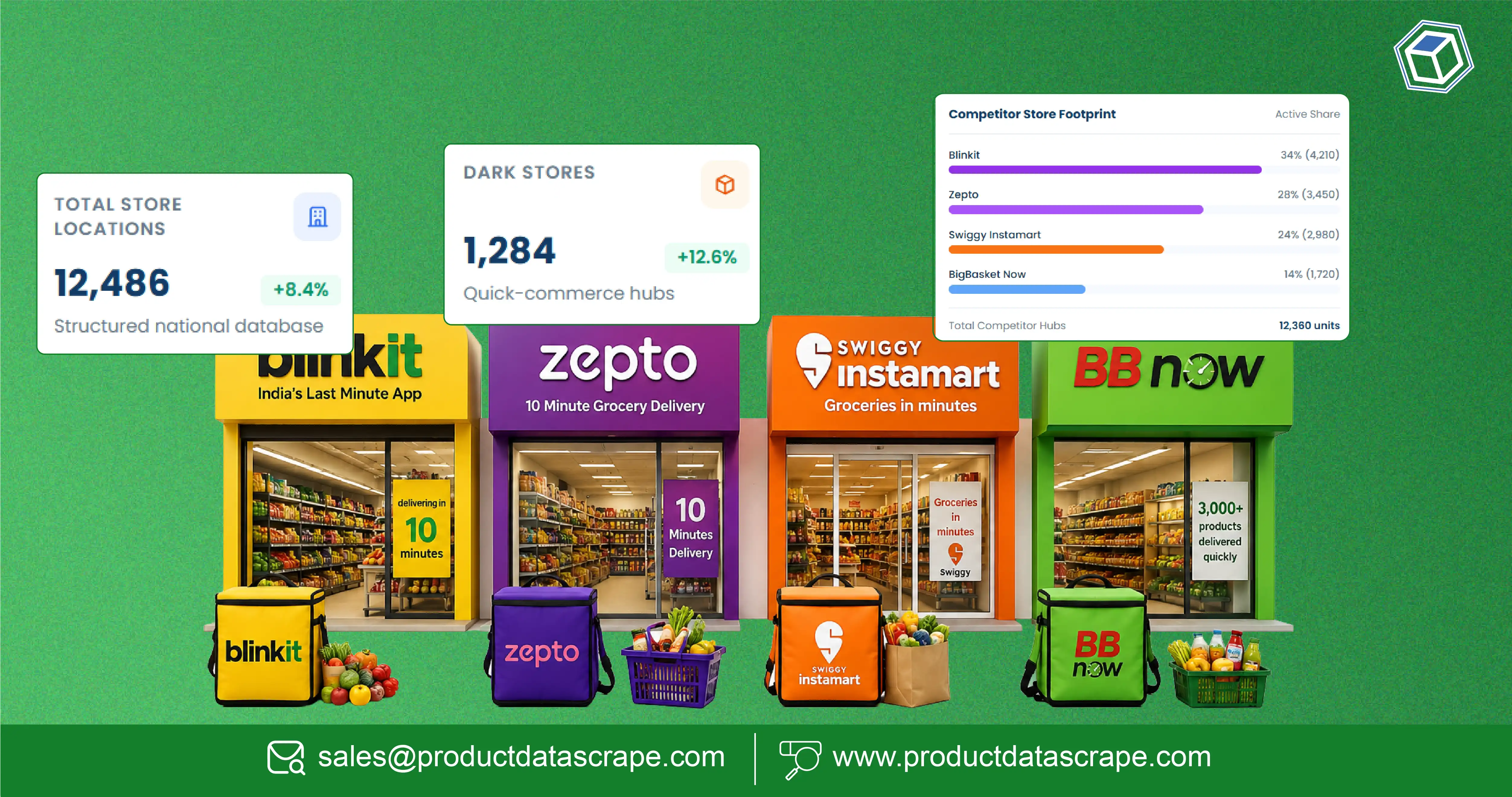
Businesses can make better expansion, logistics, and competitive decisions by collecting accurate location intelligence. Scrape Store Locations, POI & Dark-Store Geo Data helps retailers, quick commerce companies, FMCG brands, and logistics providers analyze store networks, service areas, and competitor footprints. Businesses can also Map Every Dark Store Coordinates to optimize delivery coverage, identify expansion opportunities, and improve operational efficiency.
Target Audience: Retail chains, quick commerce platforms, FMCG brands, logistics companies, market researchers, real estate analysts, and business intelligence teams.
Pain Point Solved: Many businesses lack accurate location intelligence to evaluate competitor coverage, optimize delivery zones, and select profitable expansion sites. Automated geo-data collection provides reliable datasets that support faster and more informed decisions.
According to industry estimates, the global location intelligence market continues to grow as retailers increasingly rely on geographic data to improve customer reach and operational planning. From 2020 through 2026, businesses have significantly increased investments in geospatial analytics, dark-store mapping, and point-of-interest (POI) intelligence to strengthen omnichannel strategies.
With growing demand for same-day and instant delivery, understanding store proximity, delivery coverage, and regional demand has become a competitive necessity. Accurate location datasets help businesses identify underserved markets, benchmark competitors, and optimize fulfillment operations.
Product Data Scrape provides scalable location intelligence solutions that transform publicly available geographic information into structured datasets for advanced business analytics.
Location Intelligence Trends (2020–2026)
| Year |
Industry Trend |
Business Benefit |
| 2020 |
Rapid growth of digital retail |
Increased need for geo intelligence |
| 2021 |
Expansion of quick commerce |
Better delivery planning |
| 2022 |
Growth of dark-store networks |
Improved fulfillment efficiency |
| 2023 |
Advanced geospatial analytics |
Smarter expansion strategies |
| 2024 |
Automated location intelligence |
Reduced manual research |
| 2025 |
AI-assisted site selection |
Better investment decisions |
| 2026 |
Enterprise geo-data platforms |
Competitive market advantage |
How Can Geo Intelligence Improve Expansion Decisions?
Location plays a critical role in retail success. Understanding where competitors operate, how customers are distributed, and which delivery zones remain underserved enables businesses to expand strategically instead of relying on assumptions.
Dark Store Geo Intelligence provides detailed visibility into fulfillment centers, warehouse locations, delivery coverage, and regional infrastructure. When combined with Quick Commerce intelligence, businesses gain a comprehensive understanding of competitor operations and customer accessibility.
Organizations can use geo intelligence to:
- Compare competitor store density
- Identify high-demand neighborhoods
- Analyze delivery radius coverage
- Evaluate fulfillment efficiency
- Discover expansion opportunities
- Measure regional competition
- Improve last-mile logistics
- Optimize service availability
For example, a grocery retailer planning expansion into a metropolitan area can analyze existing dark-store clusters, customer demand, and nearby competitors before investing in new facilities. This reduces expansion risk and improves return on investment.
Geo intelligence also supports operational planning. Businesses can identify overlapping service zones, optimize warehouse placement, and reduce delivery times by understanding geographic demand patterns.
Geo Intelligence Growth (2020–2026)
| Year |
Market Development |
Business Value |
| 2020 |
Digital grocery growth |
Better market visibility |
| 2021 |
Expansion of instant delivery |
Improved fulfillment planning |
| 2022 |
Larger dark-store networks |
Stronger logistics optimization |
| 2023 |
AI-assisted geographic analytics |
Faster decision-making |
| 2024 |
Real-time location monitoring |
Better operational efficiency |
| 2025 |
Predictive expansion planning |
Reduced investment risk |
| 2026 |
Integrated location intelligence |
Sustainable competitive advantage |
Businesses implementing geo intelligence benefit from:
- Better expansion planning
- Improved delivery efficiency
- Stronger competitor analysis
- Enhanced customer accessibility
- Reduced operational costs
- Smarter investment decisions
Organizations that continuously monitor geographic market changes can respond faster to evolving customer demand and maintain stronger competitive positioning.
How Can Businesses Build Accurate Store Location Databases?
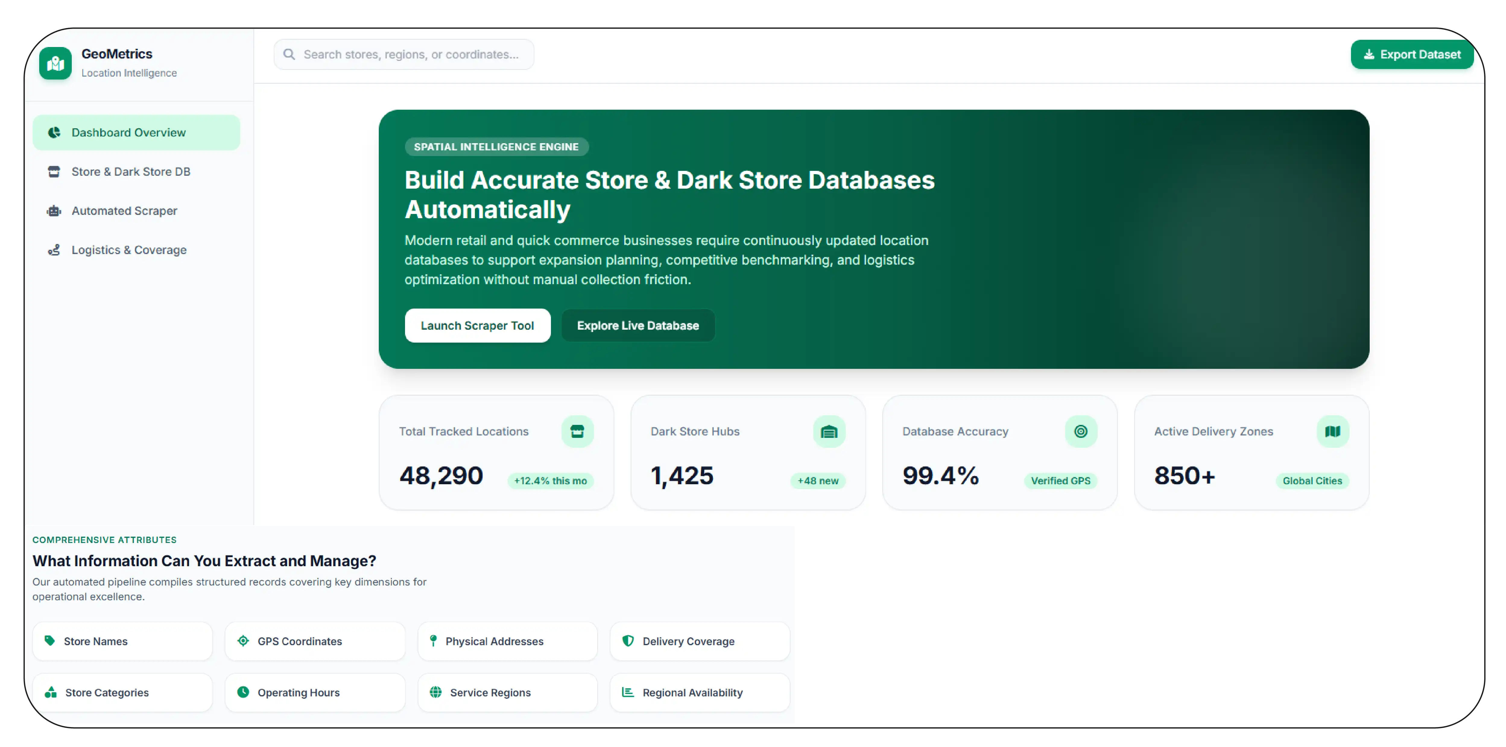
Modern retail and quick commerce businesses require continuously updated location databases to support expansion planning, competitive benchmarking, and logistics optimization. Manual collection of store information is slow, inconsistent, and difficult to maintain as networks continue growing.
Scrape Dark Store Locations Data enables organizations to automate the collection of store addresses, geographic coordinates, operating regions, delivery zones, and fulfillment center information from publicly available sources. These structured datasets support strategic planning and operational analysis.
Businesses can collect information such as:
- Store names
- Geographic coordinates
- Addresses
- Delivery coverage areas
- Store categories
- Operating hours
- Service regions
- Regional availability
For example, a logistics company can compare fulfillment center locations across multiple cities to identify underserved delivery zones. A retail chain can analyze competitor store density before selecting locations for future expansion.
Accurate store location databases also improve mapping, routing, and territory planning. By maintaining current geographic information, businesses reduce operational inefficiencies and make location-based decisions with greater confidence.
Store Location Data Trends (2020–2026)
| Year |
Development |
Business Impact |
| 2020 |
Basic store mapping |
Initial location visibility |
| 2021 |
Expansion of delivery hubs |
Improved coverage analysis |
| 2022 |
Automated location collection |
Greater data accuracy |
| 2023 |
Real-time geographic updates |
Faster operational planning |
| 2024 |
Enterprise location datasets |
Better analytics integration |
| 2025 |
Predictive site selection |
Optimized expansion |
| 2026 |
AI-powered geo intelligence |
Long-term strategic planning |
Organizations using automated location databases gain several advantages:
- Faster market research
- Reliable geographic information
- Better delivery planning
- Improved competitor monitoring
- More accurate expansion strategies
- Enhanced business intelligence
As retail and quick commerce networks continue expanding through 2026, accurate location datasets will remain essential for organizations seeking sustainable growth and operational excellence.
How Can Businesses Connect Location Data with Operational Intelligence?
Retailers and quick commerce companies need more than a list of store addresses. They require structured location intelligence that integrates with operational systems, delivery planning, and market analytics. Combining geographic information with business applications helps organizations make faster and more accurate decisions.
Store Location Data Scraping enables businesses to collect publicly available information such as store names, addresses, coordinates, operating hours, delivery coverage, and service availability. When combined with Quick Commerce APIs, organizations can automate data updates and integrate location intelligence into dashboards, GIS platforms, logistics software, and business intelligence tools.
Businesses can use integrated location data to:
- Monitor competitor store expansion
- Compare delivery coverage
- Optimize fulfillment operations
- Analyze regional demand
- Improve territory planning
- Build executive dashboards
- Support expansion forecasting
- Enhance customer reach
For example, a quick commerce company planning expansion into new cities can combine geographic datasets with API-driven operational metrics to evaluate delivery speed, service coverage, and customer accessibility before opening additional fulfillment centers.
Integrated location intelligence also reduces manual reporting by ensuring decision-makers have access to continuously updated geographic information across multiple business systems.
Location Integration Trends (2020–2026)
| Year |
Industry Development |
Business Benefit |
| 2020 |
Digital mapping adoption |
Better visibility |
| 2021 |
API-based location services |
Faster integration |
| 2022 |
Automated geographic updates |
Improved accuracy |
| 2023 |
GIS and BI platform integration |
Smarter reporting |
| 2024 |
AI-assisted operational analytics |
Faster decision-making |
| 2025 |
Predictive location planning |
Optimized investments |
| 2026 |
Enterprise location ecosystems |
Sustainable growth |
Businesses integrating location intelligence gain several advantages:
- Faster operational reporting
- Better expansion planning
- Improved logistics efficiency
- Unified business intelligence
- Reduced manual effort
- Enhanced customer service planning
As omnichannel retail continues evolving, integrated location intelligence will remain essential for organizations seeking scalable and data-driven growth.
How Can POI Insights Improve Market Analysis?
Understanding nearby amenities and surrounding commercial activity is critical for selecting profitable retail locations. Businesses need detailed information about restaurants, supermarkets, pharmacies, transportation hubs, residential areas, and other nearby points of interest to evaluate market potential accurately.
POI Data Extraction Services help organizations collect publicly available information about nearby businesses, landmarks, infrastructure, and commercial zones. These datasets provide valuable context for expansion planning, competitor analysis, customer accessibility, and real estate evaluation.
Businesses can analyze:
- Retail clusters
- Shopping centers
- Residential communities
- Transit stations
- Hospitals
- Schools
- Office complexes
- Entertainment venues
For example, a grocery retailer evaluating a new dark-store location can assess nearby residential density, competing supermarkets, public transportation access, and complementary businesses before making an investment decision.
POI intelligence also supports logistics optimization by helping companies understand delivery accessibility, traffic patterns, and customer convenience. Combined with geographic datasets, POI analysis creates a complete picture of local market conditions.
POI Intelligence Evolution (2020–2026)
| Year |
Market Trend |
Business Value |
| 2020 |
Digital map adoption |
Better location visibility |
| 2021 |
Growth in commercial mapping |
Improved expansion planning |
| 2022 |
Automated POI collection |
Greater data accuracy |
| 2023 |
Smart city analytics |
Better infrastructure insights |
| 2024 |
AI-powered location intelligence |
Faster market evaluation |
| 2025 |
Predictive site analysis |
Reduced investment risk |
| 2026 |
Enterprise POI ecosystems |
Long-term strategic advantage |
Organizations using POI intelligence benefit from:
- Better site selection
- Improved market research
- Enhanced competitor analysis
- Stronger customer accessibility planning
- Optimized delivery coverage
- Smarter investment decisions
As location-based competition increases across retail and quick commerce, businesses that continuously analyze surrounding commercial environments will make more informed expansion and operational decisions.
How Can Businesses Use Geographic Intelligence to Improve Competitive Advantage?
Retailers and quick commerce providers operate in highly competitive markets where fulfillment speed and service coverage directly influence customer satisfaction. Businesses need reliable geographic intelligence to monitor competitor locations, evaluate delivery reach, and identify underserved markets. Accurate location insights support better operational planning and long-term expansion.
Dark Store Geo Data Scraping enables organizations to collect publicly available information about dark stores, fulfillment centers, delivery hubs, service areas, and geographic coverage. These structured datasets help businesses compare competitor networks, monitor expansion activity, and improve logistics planning.
Companies can use geographic intelligence to:
- Monitor competitor fulfillment centers
- Analyze delivery coverage
- Evaluate regional market saturation
- Compare expansion strategies
- Optimize warehouse placement
- Improve route planning
- Support investment analysis
- Strengthen competitive positioning
For example, a grocery delivery company can compare competitor dark-store density across major metropolitan areas to identify locations where customer demand exceeds current delivery capacity. This helps reduce investment risk while improving service efficiency.
Geographic intelligence also supports long-term planning by revealing how competitor networks evolve over time. Businesses can track market expansion, identify emerging commercial zones, and prioritize high-growth regions using reliable location data.
Geographic Intelligence Trends (2020–2026)
| Year |
Industry Development |
Business Outcome |
| 2020 |
Expansion of delivery networks |
Better market visibility |
| 2021 |
Growth of fulfillment centers |
Improved logistics planning |
| 2022 |
Automated geo-data collection |
Higher operational efficiency |
| 2023 |
Advanced mapping technologies |
Faster expansion decisions |
| 2024 |
AI-driven geographic analytics |
Better investment planning |
| 2025 |
Predictive network optimization |
Reduced operational costs |
| 2026 |
Enterprise location intelligence |
Sustainable competitive growth |
Businesses implementing geographic intelligence benefit from:
- Better fulfillment planning
- Improved market coverage
- Faster expansion decisions
- Reduced operational costs
- Enhanced competitor monitoring
- Stronger customer accessibility
Organizations that continuously monitor geographic market changes gain a measurable advantage in the rapidly evolving quick commerce and retail landscape.
How Can Accurate Location Datasets Support Better Business Decisions?
Reliable location datasets are the foundation of successful expansion, logistics optimization, and competitive analysis. Businesses require consistent, structured, and regularly updated geographic information to support operational planning and business intelligence initiatives.
A comprehensive Store Address & Geo Coordinates Dataset provides detailed information about retail stores, dark stores, fulfillment centers, service locations, and delivery coverage. Businesses can integrate these datasets into GIS software, analytics platforms, CRM systems, and business intelligence dashboards to improve decision-making.
Typical location datasets include:
- Store names
- Complete addresses
- Latitude and longitude
- Postal codes
- City and state information
- Store categories
- Delivery availability
- Service regions
- Geographic boundaries
- Historical location updates
For example, a national retailer can compare competitor store locations across multiple cities to identify underserved markets before launching new outlets. Logistics providers can optimize warehouse placement by analyzing customer proximity and delivery routes using accurate coordinate datasets.
Structured geographic data also improves forecasting, territory management, and market segmentation by providing a reliable foundation for advanced analytics.
Location Dataset Evolution (2020–2026)
| Year |
Dataset Advancement |
Business Impact |
| 2020 |
Basic address databases |
Initial geographic visibility |
| 2021 |
Digital coordinate mapping |
Improved location accuracy |
| 2022 |
Automated dataset generation |
Faster updates |
| 2023 |
Enterprise GIS integration |
Better reporting |
| 2024 |
AI-supported geographic analytics |
Smarter planning |
| 2025 |
Predictive location intelligence |
Expansion optimization |
| 2026 |
Unified enterprise datasets |
Long-term strategic growth |
Organizations using structured geographic datasets gain several advantages:
- Improved site selection
- Better delivery planning
- Faster competitor analysis
- Accurate market segmentation
- Enhanced operational efficiency
- Reliable business intelligence
As retail and quick commerce continue expanding through 2026, businesses that leverage comprehensive location datasets will be better equipped to optimize operations, improve customer reach, and achieve sustainable growth through data-driven geographic intelligence.
Why Choose Product Data Scrape?
Businesses need accurate location intelligence to make confident expansion, logistics, and competitive decisions. Dark-store inventory insights combined with Scrape Store Locations, POI & Dark-Store Geo Data enable organizations to understand fulfillment networks, optimize delivery zones, benchmark competitors, and identify underserved markets. Our automated data collection solutions deliver structured, reliable, and scalable datasets covering store locations, POIs, geographic coordinates, and service areas. With customized data delivery, API integration, and enterprise-ready analytics support, businesses can reduce manual research, improve operational efficiency, and make faster, data-driven decisions across retail and quick commerce markets.
Conclusion
Location intelligence has become a strategic asset for retailers, FMCG brands, logistics providers, and quick commerce businesses. By leveraging Geo and store-level pricing data alongside Scrape Store Locations, POI & Dark-Store Geo Data, organizations can optimize expansion strategies, improve delivery operations, benchmark competitors, and uncover new market opportunities.
With advanced location intelligence solutions from Product Data Scrape, businesses gain accurate geographic datasets that support smarter planning, better operational efficiency, and long-term growth.
Ready to strengthen your location intelligence strategy? Contact Product Data Scrape today for customized geo-data solutions tailored to your business needs!
You can also reach us for all your mobile app scraping, data collection, web scraping, and instant data scraper service requirements!
FAQs
1. Why is location intelligence important for retail expansion?
Location intelligence helps businesses identify high-potential markets, evaluate competitor presence, optimize delivery coverage, and select profitable store locations using accurate geographic and market data.
2. What information is included in store location datasets?
Datasets typically include store names, addresses, geographic coordinates, operating regions, service areas, business categories, and other publicly available location attributes.
3. How can Product Data Scrape support geo-data collection?
Product Data Scrape provides scalable location intelligence solutions with automated data extraction, structured geographic datasets, custom integrations, and analytics-ready data for retail and quick commerce businesses.
4. Which industries benefit from dark-store and POI intelligence?
Retail, FMCG, logistics, real estate, quick commerce, consulting, investment, and market research organizations use geographic intelligence to improve operational and strategic decisions.
5. How frequently should businesses update location datasets?
Businesses should refresh geographic datasets regularly to reflect store openings, closures, service area changes, and market expansion, ensuring accurate planning and competitive analysis.


 Singapore
 EMAIL
EMAIL
 PHONE
PHONE










.webp)